5 lakes, 15 cities, 23 days…
3816 miles, 151.035 gallons of premium unleaded
The Journey Begins…
…at Annandale, VA, around 8:00 a.m. on August 12, 2000, bound for Elkhart, Indiana. The weather started out beautiful and pretty much stayed that way for the entire trip; the only real rain encountered was on the last day driving back to Annandale. This first day was to be a “fly-by-car” day, which necessarily meant interstate highways, which, unfortunately, meant toll roads for the majority of the day. I don’t really object to toll-roads as long as they offer some advantage, such as better maintenance (that is, better, smoother surface), less traffic, higher speed limits, or no trucks. This, however, is not the case with most of the toll-roads that stretch from New Jersey across Pennsylvania, Ohio, and Indiana into Illinois. The majority of these states (all of them except Indiana) apparently just pocket the tolls and maintain the roads to only the minimum extent necessary. You’ll hear more about the roads as we go along – probably more than you want to 😉
As usual while flying-by-car, audio books were the order of the day (note the use of the generic term, and not the term Books on Tape, which is just one specific vendor). The two standouts on this 600+ mile leg of the journey were I Ain’t Got Time to Bleed, by Jesse Ventura (who also did the reading), and A Walk in the Woods, a book by Bill Bryson about his adventure hiking the Appalacian Trail (I thought this was particularly fitting, as this was the first day of a three week adventure). I can highly recommend both books, in either audiotape or paper format, without reservation. And no, these two books did not consume all of the 13+ hours of driving on this day, but the others just weren’t that memorable.
Crossing the line into Indiana in the late afternoon, with the sun low in the sky, it was time to both refuel the car and get something to eat. The signs said that Elkhart was still a few hours away, so I started reading the exit signs to see which ones had both gasoline and an interesting restaurant. Nothing presented itself, so after a few exits I just decided to get off the highway and hope for the best. The randomly chosen exit lead into Howe, IN.
Now Howe, IN, is literally a one stop town, but they did have a gas station. After refueling, I cruised around town for a few minutes and found Blondie’s, a genuine soda fountain and diner right out of the 1950’s. The outside looked like something from American Graffiti, and the inside pretty much did too, with juke box, lunch counter, and booths. The motif was a cross between an Elvis shrine and a classic car paradise (there were die cast models of almost any American muscle car you can name, and then some). If you ever get to Howe, IN, I highly recommend you stop by Blondie’s, at 405 Third St, Howe, IN, 46746. The food – hot dogs, sausage dogs, fries, ice cream delites (sic), and malts (real malts!) – is good and the service is great (from Blondie herself no less).
The rest of the drive to Elkhart, IN, was uneventful but filled with reflection on the first day on the road. I arrived at the hotel about 11:00 p.m. and was asleep soon after.
The second day was also mostly a travel day, but not quite fly-by-car, although it was still all Interstate/Toll-Road. I continued west out of Elkhart, IN, and on into Illinois. The roads in Indiana were good, but crossing into Illinois returned me to those old, familiar, neglected toll-roads. I bypassed Chicago and headed northwest toward Wisconsin. Once into Wisconsin, the roads were excellent. In fact, the roads in Wisconsin were the best of the entire trip; they were consistently well-maintained, with beautiful rest stops that had spotless rest rooms and perfectly manicured picnic areas. The picnic areas were so nice that I wished I had packed a lunch (I did buy a soft drink from their machine and drank it as I relaxed at one of the tables).
Continuing northwest toward the Dells of Wisconsin, the traffic on the northbound side of the Interstate (the side I was on) was pretty light and moving well. The traffic on the southbound side was almost completely stopped and was bumper to bumper for miles. I began to wonder if they knew something I didn’t, but I pressed on.
The Dells of Wisconsin
I arrived at the Dells of Wisconsin about mid-afternoon on Sunday, August 13, 2000. The dictionary defines dells as the rapids of a river, but the Dells of Wisconsin are more than that. They comprise a 7 mile long gorge that was cut by the Wisconsin River, in an area that remained glacier-free during the most recent Ice Age. The Dells are now split into the Upper Dells and the Lower Dells by a small hydro-electric dam. The Upper Dells is now, of course, pretty much just a small lake, but the Lower Dells still has the exposed, colorful rock formations that were carved by the river over who knows how many thousands of years.
After I checked into the hotel and got some dinner, there was still time to catch Tommy Bartlett’s Thrill Show, one of many tourist attractions in The Dells (actually, The Dells is nothing but tourist attractions). The Thrill Show lasted about two hours, with a water-ski show for the first half, then a short intermission to allow the audience one last chance at the snack bar and gift shop, followed by about an hour of what can only be described as a variety show in the best Ed Sullivan tradition. The water-skiing was okay but was not up to the standards of, say, Cypress Gardens in Florida. The variety show started out okay, then kept getting better. The last two acts were really good, with the very last one being the best of the evening – a combination juggler and comedian who was excellent. Overall the Thrill Show was worth the money, and I’d recommend it.
After breakfast the next morning, I looked at the AAA tour book to find some interesting ways to spend the day. Since I was spending two nights in The Dells, the whole day was available. One thing I knew I wanted to do was take the boat tour of the Lower Dells (the half where you can still see the exposed, colorful, eroded rock), but since the weather was cool and overcast I decided to wait until early afternoon, hoping it would be warmer and clear. So I decided to visit the local Deer Park and Petting Zoo first.
Now, going to a Deer Park and Petting Zoo doesn’t sound like something I’d normally do, but I was on vacation and willing to try something out of the ordinary. It was great! I got to the Deer Park early enough that it still wasn’t crowded (well, it never got crowded by Northern Virginia standards), so I bought my ticket (all of $4, as I recall) and some special “Deer Food,” and entered the arena. I call it an arena because the deer know why you’re there – they know you have food for them. As soon as I stepped through the gate I was immediately the subject of intense interest.
It didn’t take long to go through all of the Deer Food I’d purchased with my ticket, but not to worry, there were several strategically placed stands around the arena where one could buy more. There were even a few bubble-gum type machines where you put in a quarter and get a handful of food; this turned out to be the most efficient way to feed the deer, since several of them knew where the food comes out and they would open the cover and eat the pellets right out of the dispenser as soon as you turned the knob. No muss, no fuss. There were other animals around too, but most of them were in “habitats” separated from the arena by fencing or chicken wire. A good time was had by all, especially the deer!
After the Deer Park, it was still pretty overcast, so I decided to see what else I could get into around the area. It wasn’t long before I noticed a recurring theme around the Dells – Go Kart tracks! It seemed like there was one every block or so, on both sides of the main drag. After scoping out a few, I decided to try out the one that had the largest number of unique tracks; that it also appeared to be less busy than the others didn’t hurt either.
The karts on most of the tracks were the very tame, “kiddie” type of karts, which meant that the tracks weren’t very challenging. Just put the pedal to the metal and steer. Ho-hum. However, they did have one track where the karts were a bit faster and the track was smooth and twisty. It was still possible to keep the throttle wide open all the way around as long as you stayed on the “racing line.” Drivers on this track were required to be at least about four and a half feet tall, so there were no small children driving. In fact, other than me there were only two other drivers: a thirty-something oriental man and his approximately ten year old daughter. The man was pretty timid, but the little girl was sprinting right along. Alas, she wasn’t paying any attention to the apexes of the corners, so she was lifting and losing speed on most of the turns. After passing her father early on, I was finally able to catch and pass her before the end of the session. Not exactly what I’d call exhilarating, but not bad for a few bucks.
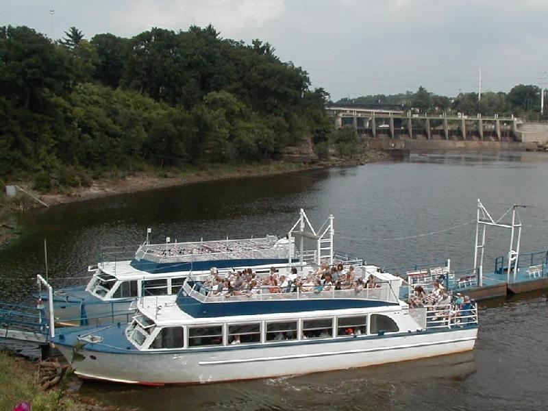 By this time it was early afternoon, and the weather had cleared about as much as it looked like it was going to, so it was off to the boat tour of the Lower Dells. The boat that I was on was not very crowded, so everyone was able to sit inside, which was nice since it was still a little too chilly to be comfortable out in the wind. The boat takes about an hour to cover approximately 8 miles of river (well, really 4 miles, since the return trip is over the same part of the river). The tour guide was a local college student who had the history of the Dells and the other banter down pat, yet still seemed to be excited about sharing that information with tourists. When he wasn’t doing “the spiel”, he sang a couple of songs – and he was pretty good! It was still a bit overcast, but that, as they say, is life.
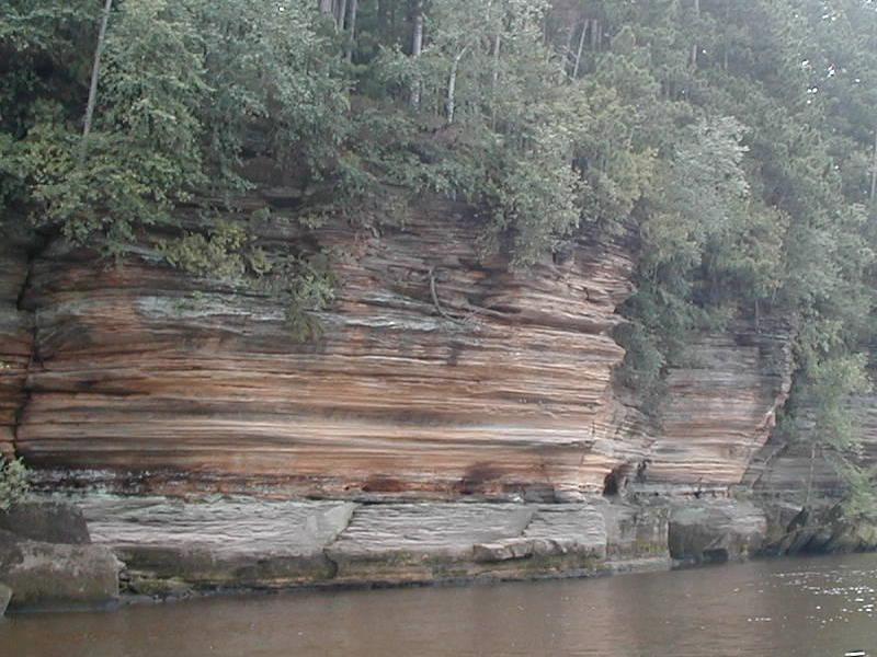 The photo to the right is a typcial scene from the boat on the tour of the Lower Dells…
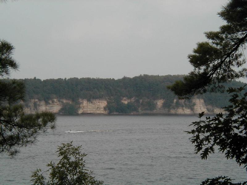 This is a typical view of the Upper Dells. I did not take the boat tour of the Upper Dells, but I did do a little hiking along the shore.
After all this excitement, I returned to the hotel to clean up and decide what to do next. It was late afternoon so my thoughts turned to food. As it turns out, there is a fairly large Hungarian contingent in the area (who knows why), so there is the obligatory authentic Hungarian restaurant. The restaurant had a buffet complete with stuffed cabbage leaves as well as other Hungarian delicacies. The food was really very good.
After dinner I headed over to see a Magic Show at the Rick Wilcox Theater (hey, the Dells of Wisconsin is, after all, a prototypical tourist area with all the trappings, no pun intended ;-). The Magic Show was okay, but I liked Tommy Bartlett’s Thrill Show better.
The next morning (Tuesday, Aug 15, 2000) I checked out of the hotel and found a Perkin’s Pancake House for breakfast. While I would not travel 900 miles just to see the Dells, if you’re in the area they’re worth a look. In retrospect, a day or so at a tourist trap is a pretty good way to transition from the hectic, Washington D.C. daily working life to a relaxed, three week road trip.
The Twin Cities
I spent three nights in the Minneapolis, Minnesota area. While there, I spent an afternoon at the Mall of America, reputed to be the largest indoor shopping mall in the universe, and I, for one, believe it. They really need to put in some type of mass transit inside the mall! Later in the evening I had dinner at the Gasthaus – Bavarian Hunter, an authentic German restaurant in the small town of Lake Elmo, MN. The atmosphere was very much like that of a restaurant in Germany, and the food was too. In fact, I had my first real schnitzel since my last trip to Germany (which was around 1989 as I recall), and it was certainly the best schnitzel I’ve had on this side of the Atlantic.
Touring around the countryside of rural Minnesota, I discovered an ice cream flavor called Moose Tracks. I’m still not sure exactly what was in it, but it was great, and I was to run across it again and again while in northern Minnesota, Wisconsin, and Michigan. Haven’t been able to find it anywhere else; if you run across it, and if you like ice cream, you should definitely try some. Update: “Moose Tracks” ice cream is made by Mayfield Dairy, and is now available in at least parts of Georgia and South Carolina. I haven’t seen it in Northern Virginia yet, but I’ll keep looking. On second thought, maybe it’s best if they don’t bring it up here after all 😉
I left the Minneapolis area on Friday morning, August 18, 2000, bound for Ashland, Wisconsin. Instead of taking the most direct route, which would have been roughly northest, I drove pretty much due north toward Duluth, MN. While this did take considerably longer, it had the advantage of allowing me to drive along the entire southern shore of Lake Superior, from Duluth, MN, to Paradise, MI.
Lake Superior
The southern approach to Duluth, MN, becomes increasingly hilly the closer you get to the city. This means that you really can’t see Lake Superior until you get pretty close. Since I had not been to the area before, I really didn’t know what to expect, and was quite surprised when I crested a hill and suddenly below me lay the city of Duluth with the Big Lake stretching beyond it to the horizon. What a breathtaking sight. If there had been a place to pull over and park the car, I would have happily enjoyed that sight for a little longer, and I’d have taken several photos as well. Unfortunately, the terrain at that point on the Interstate has no place for a rest stop or even a scenic overlook.
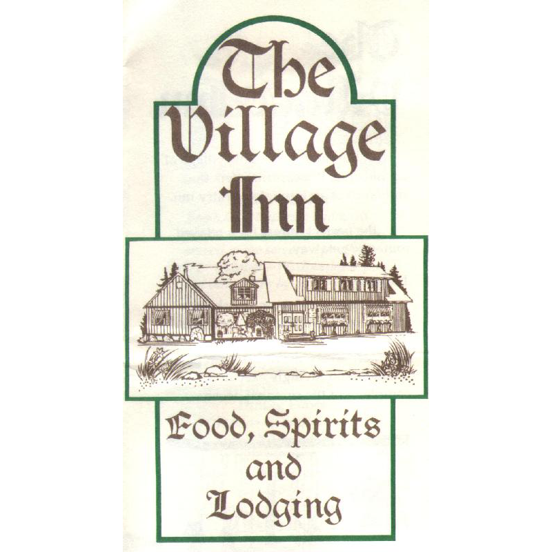 I traveled along the the southern shore of the Big Lake to the city of Ashland, WI., which is on the “mainland” directly south of the Apostle Islands. After checking in at the hotel (the Best Western Holiday House in Ashland, Wisconsin – perhaps the grungiest Best Western I’ve ever seen) I set out to find an interesting place to eat dinner.
What I found was the Village Inn in Cornucopia, WI, which turned out to be an excellent restaurant offering several varieties of local fish. They also have several guest rooms, any of which would have been less expensive than the room at the Best Western, and probably nicer, too, but who knew? I arrived at the Village Inn, without a reservation, at approximately 7:20 p.m., and was told that I could be seated at 8:00 p.m.
Since I had a little over half an hour to wait, I decided to take a drive along the lake and try to find a place to sit and relax for a few minutes before dinner. The hostess at the restaurant said that there was a public beach (is it still called a beach if it isn’t at the ocean?) just a little way up the road to the north, just past the power station on the left. Well, I thought that sounded like just the spot so off I went.
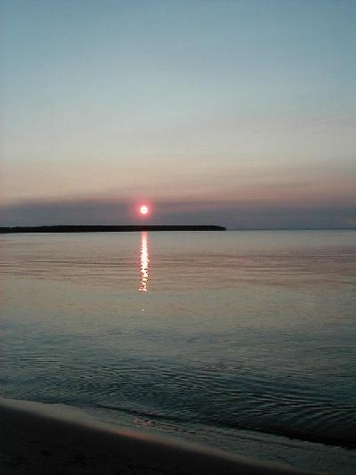 Now, currently living in a relatively large metropolitan area, when I started looking for a power station I was looking for something pretty sizable – at least as big as a two story house – so I drove right by the Cornucopia-sized power station, which was about the size of a large tool storage shed and was only a 30-second drive north of the the Village Inn. After driving about ten minutes, and approaching the city limits of the next town up the road, I decided I must have missed it and doubled back. All’s well that ends well, and I found the beach just in time to take a short stroll down to a bench where I sat to watch the sun set over the Big Lake. What a sight!
I returned to the Village Inn at the appointed time, waited in the restaurant’s bar for a few minutes, then got seated and had an exquisite meal. I had the local whitefish, which was absolutely marvelous. I wonder if that’s what Whitefish Bay, at the eastern end of Lake Superior, is named for? The meal came with the normal bread, salad, and veggies. After dinner I enjoyed an unhurried late evening drive back to Best Western Hell, er, Holiday House, where parking had become non-existant. I did finally find a spot on the other side of the hotel from where my room was located, and I got a good night’s sleep before the fairly long drive from Ashland, WI to Marquette, MI.
On the drive from Ashland to Marquette, I took a detour and visited the Porcupine “Mountains,” located right by the lake just east of the Wisconsin-Michigan border. This area is significant as it is reputed to have the largest stand of old-growth hemlock trees outside of upstate New York. I did see a lot of old hemlock as I hiked up to a point overlooking the Big Lake. This area is also significant if you like uncrowded, twisty two-lane roads. The roads getting to the Porcupine Mountains Wilderness Preserve weren’t particularly smooth, but once in the “mountains” the surface improved. And the speed limit on these mountain roads was 55, which was actually faster than I was willing to travel most of the time. A nice place to drive on a clear, sunny day.
Marquette, Michigan
I arrived in Marquette, MI, late in the afternoon on Saturday, August 19. Upon finding the hotel, the Comfort Suites on US 41 just west of the city, I decided to add an extra night’s stay in Marquette and cancel the night in Munising, MI (Munising is only about 45 minutes east of Marquette). I did this for two reasons: (1) the Comfort Suites on US 41 just west of Marquette was a really nice hotel, and (2) I was beginning to realize that changing hotels every day was going to get really tedious (a realization that would be reinforced as the trip continued, but more on that later).
Sharing the hotel’s parking lot was a 1950’s style diner, which looked like the perfect place for dinner. It was certainly convenient – I’d pretty much had enough driving for one day so the walk over was a nice change of pace. It was pretty crowded and there was a short wait for a table. The food was pretty good, and the decor was quite interesting. After a pleasant meal, it was back to the hotel for a bit of reading and relaxing, followed by an early bedtime, as the next day promised to be a full one.
Sunday, August 20, 2000, dawned clear and sunny and about 72 degrees (you just can’t beat the Summer weather in the yoop (ryhmes with loop), as the locals refer to the U.P., the Upper Peninsula, of Michigan. The 1950’s diner (I sure wish I could remember its name!) was open for breakfast, so that seemed like a good place to get a bite to eat and decide what to do for the day.
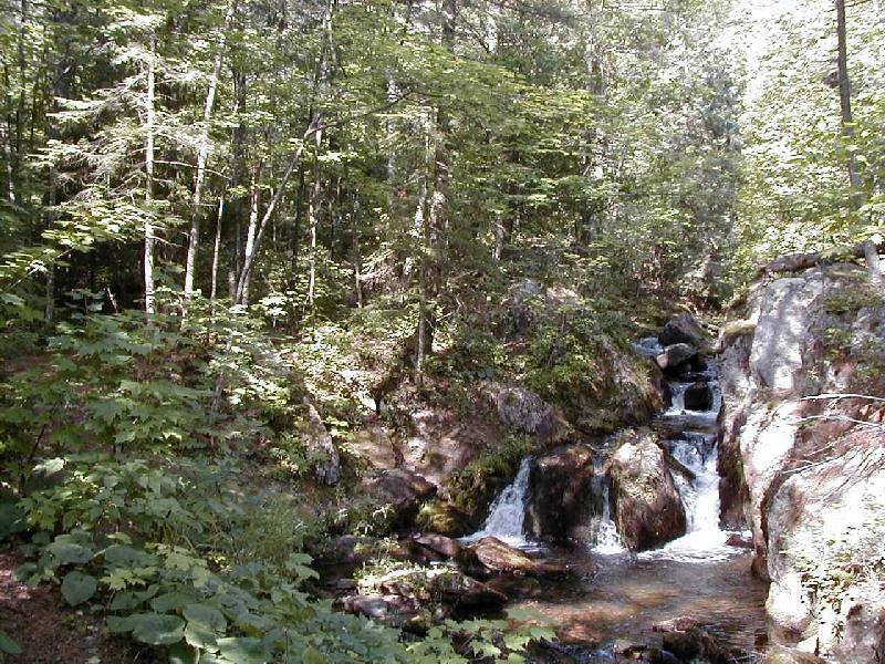 The AAA Tour Book for Michigan says that the U.P. has something like a thousand waterfalls. I like waterfalls as much as the next guy, and there was a well known waterfall nearby, so that sounded like a good place to start. Now, when I think of waterfalls, I generally get a mental picture of Horseshoe Falls (the Canadian side of Niagara Falls, which is the one you always see in the pictures). Well, Webster’s Ninth New Collegiate Dictionary defines waterfall as “a perpendicular or very steep descent of the water of a stream”, and by that definition, Reaney Falls is a waterfall. Actually, the hike to get to it was fun and interesting with several types of tree that I’d not run across before, so after I got used to the idea of what a waterfall really is it wasn’t bad at all. Actually, it turned out to be quite enjoyable.
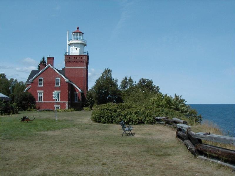 I’ve always enjoyed visiting lighthouses, and this trip provided several opportunities. The first was Big Bay Point Light, at Big Bay, Michigan. This particular lighthouse is still in operation, although the Coast Guard has replaced the original wick-type lamp with a modern electronic one. After the conversion, full-time keepers were no longer required, and, by extension, the keepers’ quarters were no longer needed, so the grounds and quarters were purchased by a private individual. They were subsequently restored (with a bit of updating) and turned into a Bed and Breakfast. For information about pricing and availability, check out their web site: www.bigbaylighthouse.com. A guided tour of both the B&B and the lighthouse tower is available for $2 about 4 times per day. I took the tour, and after seeing how nice the B&B is, decided that I’d return someday for at least a long weekend getaway.
Also during the tour of this lighthouse I learned something which, in retrospect, should have been obvious. Lighthouses are a navigational aid and not just a warning to steer clear, so each lighthouse has a unique cadence to its light. By knowing each lights particular “signature,” mariners can tell where they are at night even if they can’t see the stars. How can they tell where they are during the day when the light isn’t bright enough to see? The color scheme, pattern, and archtecture of each lighthouse varies enough so that mariners can tell where they are just by looking at the lighthouse tower. In my many previous visits to other lighthouses this never occurred to me. I now have a greater appreciation for the art of old lighthouses.
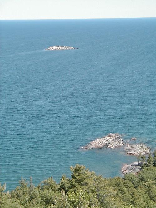 On the return trip from Big Bay to Marquette, I passed Sugarloaf Mountain Recreation Area and decided it looked interesting, so I parked the car and headed up the trail. After about an hour of hiking continuously uphill (not particularly steep, but very constant) I arrived at an observation area overlooking Lake Superior. The view was impressive. It was a clear day, so I could see all the way to Marquette, which appeared to be about 25 miles away. To the right is a photo of the lake taken from the observation area.
Upon returning to Marquette I decided to visit Presque Isle State Park, which turns out to be on a small island separated from the city by what is best described as a small stream. Still, the park was nice and had a beach area, so I was able to wade in the Big Lake for a few minutes. Actually, the water was so cold that a few minutes of wading is all I could stand, and I certainly wouldn’t want to swim in that water!
I returned to the hotel to clean up and, since it was getting near dinner time, look for a place to eat. I was pretty tired from the day’s activities, so I settled on a Red Lobster near the hotel. Yeah, yeah, I know, there are no lobsters in Lake Superior, but it was convenient and the food was predictable if not particularly exotic.
After dinner it was back to the hotel for some reading before packing and turning in early. After breakfast the next morning, I checked out of the hotel, refueled the Z, and headed east toward…
Paradise!
The drive across Michigan’s Upper Peninsula from Marquette to Paradise was remarkable, mainly for the amount of traffic that I did not encounter. Also, the roads in the U.P. were mostly very good, with only one or two exceptions, and even those weren’t anywhere near as bad as the roads around Detroit (more on that later). I arrived in Paradise (doesn’t that just sound like fun) around noon, but couldn’t check into the hotel until after 4:00 p.m., so I checked the tour books and decided to head back about five miles to the Lower Tahquamenon Falls parking area.
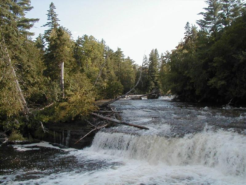 Tahquamenon Falls is really two waterfalls that are about four miles apart. The Lower Tahquamenon Falls (see photo at right) is to the east of the Upper Falls, so it’s closer to Paradise. I parked the car, grabbed my camera, and headed off to see the Lower Falls. I figured I’d spend a while at the Lower Falls then drive over to the Upper Falls and check them out, but as it turns out there is a hiking trail between the two falls so I walked the four mile distance instead.
The trail was pretty well marked and easy to follow, with mile markers at one mile intervals. It was interesting to note that as I got further from the parking area, the trail began to look less well travelled. At the halfway point the trail was so narrow that I was brushing against the undergrowth on both sides of the trail. Unfortunately, a fair bit of that undergrowth was Poison Ivy – I avoided it as much as possible, and washed up well as soon as I returned to the hotel, clothes included, and didn’t suffer any ill effects. After passing the halfway point, the trail gradually widened again as it approached the Upper Falls. I guess not too many people walk the entire distance.
 Once at the Upper Tahquamenon Falls (see photo at right) I stopped to admire the view, then headed to the concession area and had some ice cream – Moose Tracks, of course. After finishing the ice cream I retraced my route back to the Lower Falls, which was a bit easier since the net slope from the Upper to the Lower falls is downhill. I arrived at the Lower Falls parking area around 5:30 p.m. as I recall. The approximately nine mile hike had taken about four and a half hours, which included stopping for ice cream. A pretty quick pace considering the terrain.
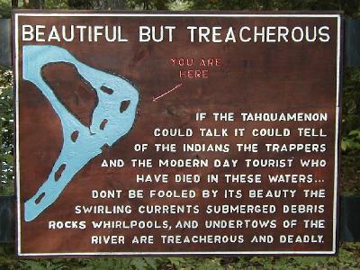 Once back at the Lower Falls end of the trail, I noticed the sign in the photo to the right. While correct puncuation would be nice, the sign nevertheless effectively indicates that jumping into the water wouldn’t be a good idea. Funny, it never even occurred to me to even think about getting in the water. Click the image for a readable version of the photo.
I got back to the hotel, checked in, took a shower, and started thinking about dinner. Asking the front desk clerk about local restaurants resulted in a suggestion to try the restaurant at the “Brew Camp.” The clerk explained that the there was a brewery near the Upper Falls before there was a state park there. The brewery was still in operation, and a restaurant serving local beer and seafood had been opened and was considered by most townsfolk to be a good place to eat. That was good enough for me and I headed off to the Upper Falls to check out the Brew Camp.
The “Brew Camp Restaurant” (I don’t remember its proper name) was right next door to the concession where I’d had ice cream earlier that day. It was pretty crowded, but a table was available within a few minutes and I had a very satisfying meal.
After dinner I headed back to the hotel to do some laundry – remember the poison ivy? I’m still kicking myself for not getting someone to take a photo of me sitting next to a hotel washing machine, since laundry is one of the things you don’t usually think of when you think about vacation. However, on a three week road trip it eventually rears its ugly head!
Tuesday, August 22, 2001 started out overcast with an occasional sprinkle – so much for Paradise! Actually, it wasn’t that bad since I’d be spending most of the day either indoors or in the car driving to the next hotel.
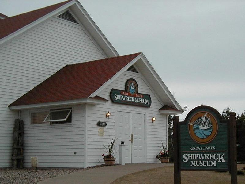 The Great Lakes Shipwreck Museum (photo at right) is a somber, yet compelling, place. The displays chronicle the misfortunes of the different types of ships that have sailed the Great Lakes, starting with the first commercial ventures and culminating with the wreck of the Edmund Fitzgerald on November 10, 1975.
The Museum is located at Whitefish Point, at the mouth of Whitefish Bay, so it’s fitting that the E. Fitz is its centerpiece, since, as the Gordon Lightfoot song reminds us, “…the searchers all say they’d have made Whitefish Bay if they’d put fifteen more miles behind her…” There’s a small theater in one of the buildings that shows a short documentary film about the E. Fitz, including recovery of the ship’s bell from the bottom of Lake Superior. The bell was recovered on July 4, 1995, presented on July 7, 1995 to the family members of the lost crew, restored by researchers at Michigan State University, and is now on display at the museum.
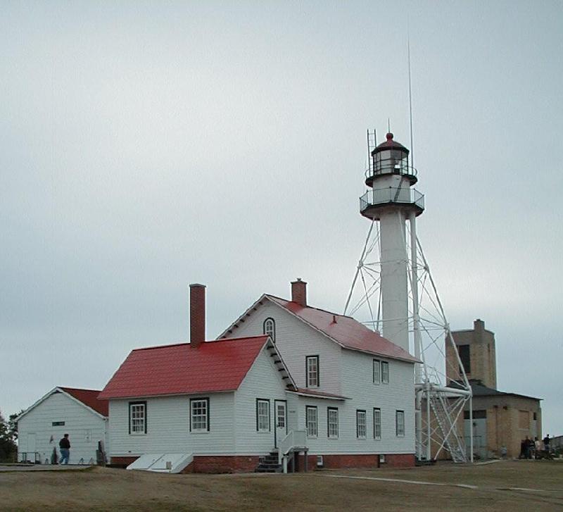 The Great Lakes Shipwreck Museum is located on the grounds of the Whitefish Point Light (photo at right), and occupies some buildings that were originally the keeper’s and helper’s quarters. Again, the quarters are no longer needed since the switch to a modern electronic light. It is my understanding that on the night the Edumund Fitzgerald sank, the storm had knocked out the power to the lighthouse, and the backup generators did not come on, so the light was dark. Ironically, if it had still been the old wick-type light, complete with a full time keeper and helper, it probably would have been lit and visible that night. Alas, it seems that would have made no difference in the outcome for the Fitzgerald, since it appears that leaking hatchways, through which the ore cargo was loaded, were the main contributing factor in the sinking.
Another line from Lightfoot’s trubute says: “Does anyone know where the love of God goes when the waves turn the minutes to hours?” The storm that night had winds from 35 to 50 knots (approximately 40 to 57 miles per hour) and generated waves from 27 to 30 feet high. In one radio communication, Ernest McSorely, the Captain of the Fitzgerald, a man with 44 years experience on the Great Lakes, reported that his ship was taking the worst seas he had ever been in. This tragedy captures the popular imagination in part, I think, because we all have dark nights when the storms in our lives cause waves that “turn the minutes to hours.”
I left the museum around noon and headed back to Paradise to mail some post cards and get a bite to eat before heading to the Comfort Inn Tahquamenon Falls in Newberry. For some reason that I do not recall I needed to actually find a person at the Post Office in Paradise instead of just dropping the post cards in the mail box. Luck would have it that the only person working at the Post Office that day was at lunch when I arrived; the sign on the door said they’d be back around 1:15 p.m., so I headed across the street to a small sandwich and ice cream shop to have lunch.
As I left Paradise, it was beginning to rain gently, so I put an audio book in the tape player and headed for Newberry. The weather in Newberry was much nicer, so after checking into the hotel I refueled the car and then looked around for a do-it-yourself car wash. I soon found one and spent all the quarters I had washing the Z. This is another of those moments I wish I’d thought to take a photo; after almost two weeks on the road the car was pretty dirty, and the front was covered with dead bugs. Again, not something that is usually associated with a vacation.
I left Newberry the next morning (Wednesday, 23 Aug 2000) and headed south on Michigan 117 to pick up U.S. 2 and head over to the Mackinaw Bridge to cross over to the lower part of Michigan. A friend that lived in Michigan, and whose wife is from the U.P., told me about a diner in the small town of Engadine called the “Engadiner.” It’s located right at the corner where MI-117 ends at U.S. 2, and I arrived there just in time for a late breakfast.
Well, let me tell you – if you’re ever near the Engadiner at meal time, definitely stop and have something to eat. Even if it’s not meal time, I’d still stop there again and just have a snack or cup of coffee. The food was excellent and the service was outstanding. The atmosphere (I just can’t bring myself to call it ambiance) was nice too. And one thing I learned there was that sugar Maples grow in the U.P., and, of course, they make Maple Syrup locally, and, of course, they sell it at the Engadiner. I had some on my pancakes, and brought back a couple of bottles for my friend and my mother – good stuff!
Lake Michigan
 Although I had essentially driven around the southern end of Lake Michigan on the way to the Dells of Wisconsin, the interstate is too far away to provide a view of the lake. So my first glimpse (see the photo to the right) of Lake Michigan was while driving east on U.S. Highway 2 along the southern coast of the U.P. As you can see from the photo, the weather was still pretty gloomy, but was improving. I was headed for the Mackinac Bridge which connects the U.P. to the “mainland” part of Michigan (I’m told that the lower part is not referred to as the L.P.)
I crossed the Mackinaw (pronounced, oddly enough, as “Mackinac”) Bridge headed south on I-75, and got off onto U.S. 31 to Levering, MI. From Levering I went west to pick up Michigan 119 at Cross Village. The reason I wanted to get on MI 119 is because it is listed as a “Scenic Road” on the AAA map of Michigan, which makes sense because it is right on the edge of Lake Michigan, and the road is actually quite a bit higher in elevation than the lake, so it should be spectacular. Well, unfortunately, you can’t actually see Lake Michigan from the road, since the narrow strip of land between the road and the lake is covered by either a dense stand of trees or a house or both.
It turned out okay, though, as the road has three saving graces. First is the road itself; it has a great surface, and it is one of the twistiest, narrowest roads (barely two car widths wide – it’s a good thing traffic was really light!) I have ever seen. Second, if you can forget about the lake that is just a stone’s throw away, it is easy to enjoy the natural beauty of the forest surrounding the road for most of its length. Third, as the coastline turns gently toward the east the road goes right through the middle of the town of Harbor Springs, MI.
Harbor Springs is absolutely enchanting. It is exactly what I pictured for the town at the beginning of Herman Melville’s classic Moby Dick. With tall sailing ships at the docks, breathtaking Victorian houses (many of which have been turned into Bed and Breakfast Inns), perfectly manicured parks, and small shops and cafes scattered about, I wished that this was my destination for the night. Alas, I had to press on without even stopping, since I still had to get to Petoskey, which it turns out is almost due south of Harbor Springs on the other side of Little Traverse Bay. If I ever get the chance, I’ll go back and spend a few days (or weeks!) in Harbor Springs.
I arrived in Petoskey, MI, in the early afternoon. Petoskey is a really nice place, and looks like it was once very similar in character to Harbor Springs. It is now much larger, and definitely caters to the tourist industry. After checking into the hotel, I headed back to the Gaslight District, the shopping area in downtown Petoskey, where, once I parked the car, I was able to walk everywhere I wanted to go. I wandered around a while and visited many small shops (including a book store where I bought a copy of W. Micheal Gear’s The Artifact, which turned out to be such a good read that I’ve since bought three more of his books), then had dinner at Andante, a four star restaurant overlooking Little Traverse Bay. The food was excellent, as was the atmosphere and service.
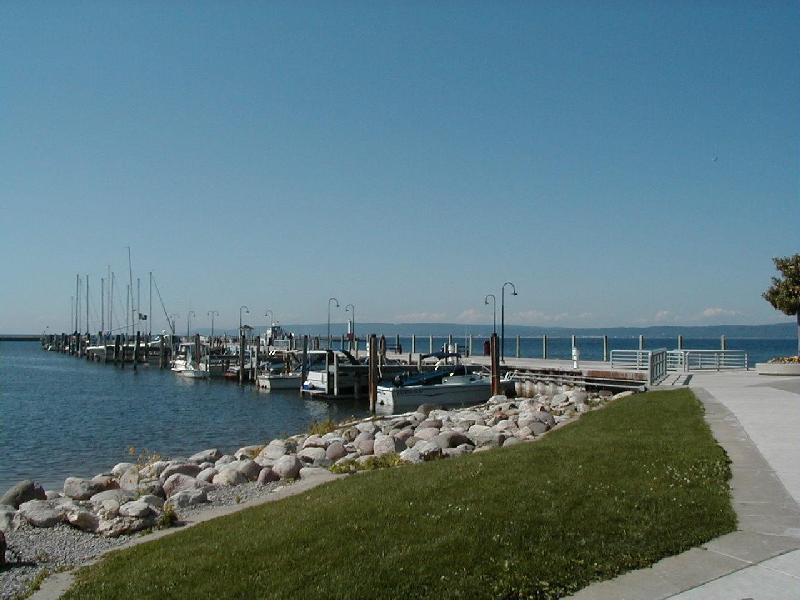 After dinner I decided to see what was playing at the nearby movie theater. It was around 8:00 p.m., which meant I had a while before the next showing, so I headed off to walk around the harbor area (see photo to the right). After walking down the piers and admiring the boats tied up there, I found a bench near the small boat launching area and relaxed as I watched several people either launch or recover their small boats. Around 9:00 p.m. I headed back to the theater.
Due to timing, the only thing playing that would be practical to see was Coyote Ugly. Sort of a romance-drama chick-flick, but it was okay. I liked most of the music so I bought the soundtrack once I got back home.
After spending only one night in Petoskey, I moved on to Traverse City, which is located at the southern end of the Old Mission Peninsula. Since it was a short drive, I arrived fairly early in the day and ventured out to visit the wineries on the peninsula. I thought the wine produced there was surprisingly good, but then I don’t really like wine, so you probably shouldn’t put too much faith in my opinion.
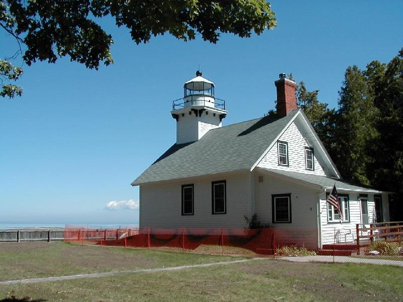 The peninsula extends into Grand Traverse Bay, and the Traverse Bay Light (see photo at right) is at the northern tip. One interesting thing about the lighthouse grounds is that the 45 degree latitude line runs through it. This means that when you are there you are exactly half way from the equator to the north pole. Oh well, I guess you had to be there…
Overall, both Petosky and Traverse City were anti-climatic. If I had known during the planning phase of this trip what I know now, I’d have skipped the nights in Petosky and Traverse City and spent two nights in Harbor Springs. Oh well.
I left Traverse City on the morning of Friday, 25 Aug 2000, and worked my way over to I-75 heading southeast toward Bay City, which is located at the joint between the “thumb” (if you look at the outline of the lower part of Michigan it looks like a mitten) and the “palm.” Unfortunately, while the roads in the U.P. had been really good, the further south I went on I-75, the worse the road got. This was to be a trend in Michigan, culminating with the worst roads I’ve ever seen anywhere in the world in Detroit. More on that later.
At Bay City I picked up Michigan Highway 25 and drove along the shore of Lake Huron to Port Austin. Actually, MI-25 doesn’t run close enough to the shore to see Lake Huron, so this part of the drive wasn’t as interesting as I’d hoped it would be, but it wasn’t too bad.
Lake Huron
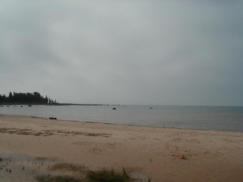
 The drive from Traverse City to Port Austin took a little longer than I’d thought it would, but I still got into Port Austin around the middle of the afternoon, which left some time to explore the area. I parked the car and walked down (or is it “up?” I was walking North, after all…) down the edge of Lake Huron, and out onto one of two concrete barriers that have been built to form a relatively well protected bay. The photo to the right was taken from near the far end of that barrier.
Michigan highway 25 enters Port Austin from the West, then makes a 90o right turn to head due South for about six blocks, the makes a 90o left turn to continue East out of town. The part that runs North-South forms what appears to be the main street of the town, and it was on this street that I found the Garfield Inn where I’d reserved a room for the night. The Garfield Inn was built in the early 1800’s, probably in the 1830’s.
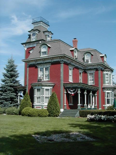 Location (only about half a mile from the lake) and architecture (notice the “Widow’s Walk” at the top of the house) suggest that it may have been built by a sea captain who sailed the Great Lakes. I asked if I could go up to the Widow’s Walk to take a look at the lake and the surrounding area, but was told that the stairs were too old and unsure to be used, which is a shame, since I’m sure that the view would have been spectacular.
It’s also a shame that the house hasn’t been maintained to a higher standard over the years. Sure, the house looks great from a distance, as in this photo. But a closer look reveals chipped and peeling paint, damaged wood, and other signs of poor maintenance. Management at the Garfield Inn also seems to be somewhat lacking. When I arrived I made a reservation to have dinner in the very nice looking restaurant on the ground floor of the Inn, but when my reservation time came and I walked down the stairs, I was told that the restaurant was short staffed that evening and that it would be at least an hour before I could be seated. It’s true that when I’d arrived earlier in the day I’d witnessed what appeared to be a “spirited” meeting of the kitchen and serving staff, which culminated in the abrupt departure of at least one employee, so I’m sure they were, in fact, short staffed. Oh well. I decided to wander back down toward the lake and found a very nice restaurant and grill where I had a nice, quiet dinner before turning in for the evening.
 I did enjoy my stay at the Garfield Inn, and I’d stay there again if I was going to be in the area. Ascending the stairs and entering the bedroom is like stepping back into the mid-1800s. The room was well appointed with what are presumably genuine antiques, including the bathtub with ball-and-claw feet.
The only signs that one hasn’t returned to a kinder, gentler yesteryear are the electric lights, the electric clock on the bedside table (which looked to be about 30 years old), and…
 …the television (click on the image to get a larger version, then take a look at the mirror on the dresser and you’ll see a reflection of the TV). I don’t think I even turned it on, and I’d have been happy to spend a night without it just to not have had one in the room, but I guess some guests aren’t that progressive (or should that be regressive?) as I. There was also a window air conditioner in the room, which I didn’t need since it was mid-August, and reasonably cool (I needed a blanket during the night). But I guess there are about 10 minutes or so sometime in the middle of July when the temperature in Port Austin gets up into the 80’s when you’d really need the AC 😉
I woke up on Saturday, August 26,2000, under a down comforter in a queen size four poster bed, with the sun shining in through the window and birds singing in the trees outside. After a wonderful shower in the antique tub, I dressed and proceeded downstairs to the restaurant where the included full breakfast is served. On this particular morning the Chef had elected to make blueberry pancakes complete with real Maple syrup, along with both sausage and bacon, and scrambled eggs on the side. Of course, juice and coffee were available in abundant quantities, as was the hospitality of the serving staff. I sat at a table with a Canadian couple that visited the lower Michigan area often, and we had a pleasant conversation about travel in general, and the Detroit/Windsor area specifically.
After breakfast, I returned to my room and brushed my teeth, then packed, loaded the car, and headed for the Detroit, MI and Windsor, Ontario, Canada area. The plan was to head to the Best Western Continental Motor Inn in Windsor, where I’d be spending the next couple of nights, and if I got there early enough, I’d head back into Detroit to have a look around. The trip took a bit longer than I’d anticipated, and when I finally arrived at the hotel in Windsor it was almost time for dinner, so I had a relaxing meal at the hotel’s restaurant, then settled down to read a bit before getting to bed early. I’d be spending the next day in Detroit, and wanted to be as well-rested as possible.
The Motor City
Sunday, August 27, 2000, dawned bright and early. I had a quick breakfast, again at the hotel’s restaurant, before I headed back over the bridge to Detroit. The breakfast menu included the usual array of eggs, omelettes, pancakes, waffles, sausage, bacon, etc., but I noticed that they also had something called “peameal bacon.” I asked the waitress what this was, and how it differed from regular bacon, and she said it was more like a round piece of ham. Being a fairly adventurous eater, I decided to take a chance and have the peameal bacon with my eggs. As it turns out, peameal bacon is what we in the U.S. call “Canadian Bacon.” Don’t we just learn something new every day?
 I crossed the bridge back into the U.S. and found my way over to I-94 which goes pretty close to Dearborn, MI, which is where the Henry Ford Museum & Greenfield Village are located. The photo to the right shows the Z parked at the Henry Ford Museum, after a horrible, harrowing drive from Windsor. The traffic was about what you’d expect early on a Sunday morning (in other words, very light); what made the drive so terrible were the potholed washboards that pass for roads in the Detroit Metro area. And I’m talking about the Interstate Highway here, not some small city street or alley, although the city streets were just as bad. It is truly unconscionable that a major American city has such poorly maintained roads, particularly in light of Detroit’s location on an international border.
And don’t talk to me about the bad weather and the “freeze-thaw” cycle that damages the roads. The roads in the upper peninsula of Michigan were in most cases in very good repair, and all of the roads in Wisconsin were better than the roads in the Detroit area, and both of those area get as cold or colder weather than Detroit. Besides, I’d argue that we actually get more “freeze-thaw” cycles in the Northern Virginia area than Detroit gets, simply because once it gets really cold in Detroit it pretty much stays below freezing even during the day, but here in Northern Virginia it freezes at night, then melts during the day, then freezes again, then melts again, and this goes on for the entire winter (not that Northern Virginia and the Washington, D.C., area don’t have some bad roads, because they do, but they’re not anywhere near as bad or as prevalent as they are in Detroit).
 And don’t talk to me about Detroit having so much traffic that they don’t have a chance to fix the roads, either, because I’m pretty sure they don’t have as much traffic as the Washington, D.C., Metro area.
So what does cause the road problems in Detroit? My guess is that it’s the number and weight of the tractor trailers and other large trucks that move steel, coal, cars, and other raw and finished goods in and out of the area, combined with too little money and time spent on maintenance. Why is this allowed? You’d have to ask the politicians in that area for the answer to that, although I could probably make a pretty accurate guess 😉
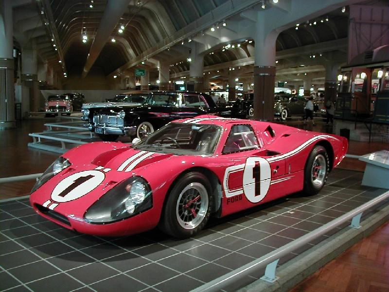 The terrible roads around Detroit notwithstanding, the Henry Ford Museum and Greenfield Village were worth visiting. The Henry Ford Museum has some interesting cars such as the 1967 Ford GT Mark IV that finally won the 24 hour race at Le Mans for Ford (see photo at right). Also on display at the museum are some whimsical vehicles like the Oscar Mayer “Wienermobile,” and some not so whimsical vehicles such as the limo in which John Kennedy was riding when he was assassinated.
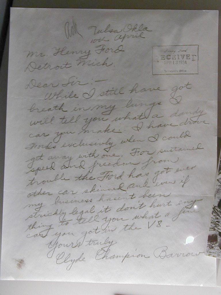 One of the more interesting items in the museum’s collection is a letter from Clyde Champion Barrow to Henry Ford (see photo at right). The museum also has lots of stuff that isn’t related to automobiles or automobilia, as well as a couple of state-of-the-art IMAX theaters.
Greenfield Village is essentially a small town that depicts small town life at the end of the nineteenth century (1800’s) into the middle of the twentieth century. Included are the actual buildings and equipment used by such men as Thomas Edison and the Wright brothers. “But wait a minute,” you say, “didn’t Edison do his thing in New Jersey, and the Wright brothers were from Ohio and went to North Carolina for their big event!” Well, that’s true, but Henry Ford had enough money, influence, and gall to purchase and then move some of the actual buildings as well as their contents to Dearborn, Michigan, when he decided to create Greenfield Village. Also on display at the Village are examples of achitecture throughout U.S. history, and many “industrial revolution” exhibits.
I really wanted to visit the Maritime Sailor’s Cathedral and Belle Isle Park while in Detroit, but I just couldn’t bring myself to subject my car to any more abuse than that which was necessary to get out of the area. For those not plugged in to Indy Car, nee CART, nee Champ Car racing, Belle Isle Park is where the Grand Prix of Detroit takes place (or took place – I think they were planning to stop racing there due to safety concerns).
All in all, if you’re going to be in the Detroit area anyway, and you have some free time, the Henry Ford Museum & Greenfield Village are worth visiting. I just don’t recommend driving your own car there – get a local rental car instead.
The Great White North and Lake Erie
On Monday, August 28, 2000, I headed east out of Windsor bound for London, Ontario, Canada. The plan was to find a road close to the north shore of Lake Erie and enjoy the view of the lake, and perhaps even stop in a small town and have lunch at a lakeside restaurant. Well, that didn’t happen. As it turns out, development is conspicuously absent from the north shore of Lake Erie – the Canadian side of the lake is nothing like the U.S. side, which is dotted with cities and resort areas. Actually, there are a couple of port cities that are on the eastern half of the north shore, but it would have been a long way out of the way to see them, so I eventually just headed directly for London.
London, Ontario, Canada, was a convenient place to stop for the night, as it’s about halfway between Windsor and Toronto. I arrived there early enough to check into the hotel, then find a coin operated lanudry to wash some clothes. I took a book to the laundry, and did manage to do some reading there, but again I could kick myself for not thinking to take my camera along – there were several people doing laundry there, and some of them were pretty interesting. Oh well, I’ll try to remember that when I do my tour of New England 😉
After finishing the laundry, I had a quiet dinner at a restaurant named, as I recall, Caribou Creek, but nobody else I’ve talked to has heard of it, and I haven’t been able to find any references to it. It was very much like an Outback restaurant, except with a Northwest Territory theme. Good food and service, and a nice atmosphere; it’s too bad they don’t have franchises around here.
The drive from London to Toronto on Tuesday, August 29, 2002, was completely uneventful. It was Queen’s Way 401 (think Interstate) all the way, so all I had to do was set the cruise control and steer. Traffic was light and moving well and the trip went pretty quickly. The only real excitement was when I started to get low on gas and began to look for place to refuel. The first one I spotted looked very convenient, so I pulled off the highway and rolled up to one of the pumps. What was exciting was that the price was marked at something like 80 cents, and those were Canadian cents, which at the time were about two thirds of a U.S. cent. “Wow,” I thought, “that’s a lot cheaper than gas in the states” (gas in the U.S. at the time was around $1.50 or so a gallon – I don’t remember exactly). Of course, what I forgot was that the price was per liter, and there are roughly four liters per gallon, so the gas was actually something like $3.20CAN per gallon. I tried not to think about it too much.
Lake Ontario
After refueling the rest of the trip to Toronto was uneventful. I did wind up missing an exit and was halfway around the city on the north side before I realized what had happened. I checked the map and there appeared to be a fairly direct route through the city, so I took that exit and headed south through the heart of Toronto. I’ll stop short of calling that a big mistake, since it was a bit of an adventure and I wasn’t really in a hurry – but I wouldn’t want to do it again! I’ve never driven in New York City, but I have driven in Los Angeles and Washington, D.C., and the traffic in Toronto was a bit heavier than either of those (in my experience), but it moved pretty well (in spite of the numerous double-parked vehicles).
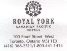 I finally found my hotel, the Royal York Canadian Pacific Hotel to be precise, and parked the Z in the underground garage. Since there was a subway stop in the basement of the hotel, I was hoping to not have to move the Z – or drive in Toronto traffic again – until I was ready to leave the area, and that’s exactly the way it turned out. I was able to either walk or take the subway everywhere I wanted to go in the city.
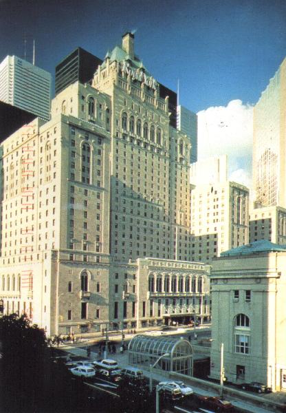 The room I had reserved was on something like the eleventh floor (I don’t remember exactly), but I asked while I was checking in which way it faced. Unfortunately, it faced the city instead of the lake. I inquired if there were any rooms available with a view of the lake, preferrably on the upper floors (the hotel is about 22 stories tall as I recall). I was in luck, there was one room available on the lake side of the hotel, on the sixteenth floor, but I was told that the fourteenth through sixteenth floors were primarily intended for buisness travellers and that they were a bit more expensive than the room I had reserved. The bit more expensive turned out to be around $100CAN per night, for a rate of $320CAN per night, plus tax. I thought for a second, then figured, why not? I was on vacation and probably wouldn’t be back to Toronto very soon (if ever), and the Royal York is a four star hotel, so I decided to enjoy a bit of luxury.
And luxury is the right word. The “business” floor had a separate, private reception desk for guests on those floors, and they offered an express checkout so that I didn’t have to wait when I was ready to leave. The private reception area also featured a complimentary breakfast buffet each morning, complete with juice, coffee and tea, and light snacks and soft drinks (as well as coffee and tea) in the afternoon. The area where these were served had several nice sofas and easy chairs, as well as tables during the breakfast time. Also available were complimentary newspapers from the major cities in North America.
The room was equally well appointed, and included a very nice terrycloth robe for use while I was a guest, and the maid came every evening while I was at dinner to turn down the bed and leave a bottle of water and a chocolate mint on the nightstand. And the view of the lake was quite spectacular.
The restaurant in the hotel was excellent, as was the concierge service. With only a one day lead, the concierge was able to get me a great table at The Second City, a comedy club in Toronto where Dan Aykroyd, Gilda Radner, John Candy, and Mike Myers, along with many others, got their start. She also made reservations for me at an Italian restaurant near the theater. Both were within walking distance of the hotel. The food was good, and the show was great, particulary the improv session after the main show.
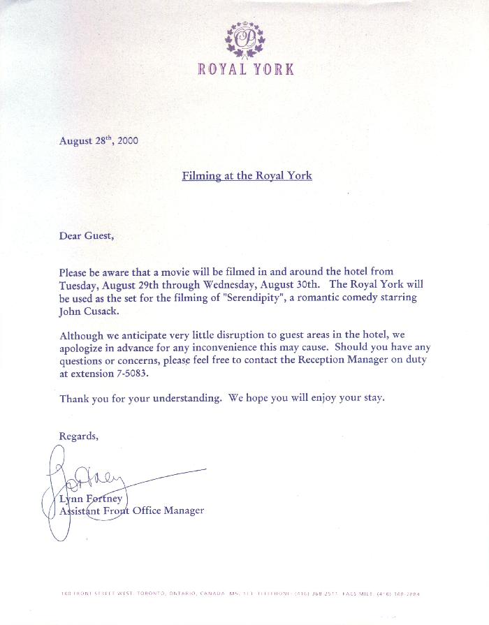 Oh yeah, they were filming part of a movie in the hotel while I was there. The movie’s title is Serendipity and stars John Cusak. The filming caused only minor disruption to the operation of the hotel, and I never saw any of the actors or anything, but I did see some of the sets they used. I haven’t seen the movie yet, but it’s on my rental list. Update! (August 2002) Serendipity finally reached the top of my rental list, and I saw it in early August, 2002, almost exactly two years after this trip. I enjoyed the movie very much. It was very well cast and acted, the production values were quite high, and the plot was good if a bit predictable (but hey, I love a happy ending 🙂 It was also fun to be able to recognize the hotel’s elevator lobby in a few scenes in the movie. Highly recommended – definitely worth renting!
So was it worth the seven-hundred-and-some-odd dollars Canadian (which translated to around $425 or so on my VISA card) to stay at The Royal York Canadian Pacific Hotel for two nights? It was to me, and that’s all that counts!
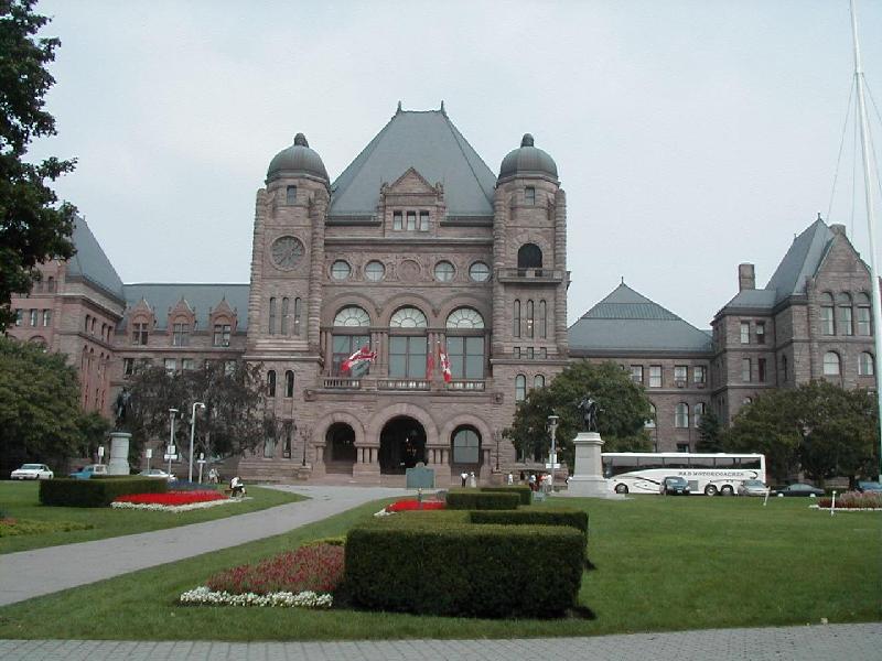 Of course, I also visited the Ontario Parliment buildings (see the photo on the right), as well as Toronto’s very impressive natural history museum. All in all, I had a great time in Toronto.
After two nights and one very busy day in Toronto, I headed east out of the city toward Kingston, Ontario, on the morning of Thursday, August 31, 2000. After an easy morning of highway cruising I arrived in Kingston in the early afternoon, early enough to enjoy a Kahlua, ice cream and chocolate syrup drink called a Mudslide at a restaurant next door to my hotel. Then I got in some reading before having a great dinner in the hotel’s restaurant and turning in early for a good night’s sleep. Other than just being a convenient place to stop for the night, I was interested in Kinston as it was to be the location for the 2001 National Z Car Convention, held in June of 2001. The host hotel had been announced just before I had left home, and it turned out that it was only a few blocks from the hotel where I was staying, so before I left the next morning to return to the U.S., I had breakfast at the convention’s host hotel and checked out the available facilities. I also went ahead and made my reservation’s for the Z Car Convention while I was there.
After breakfast I headed east toward the Thousand Islands Bridge, which spans the St. Lawrence Seaway a few kilometers east of Lake Ontario. As I got onto the Queen’s Highway, I noticed that I had very little gas left in the tank – so little that the warning light was on. I didn’t really want to buy any more gas at Canadian prices, so I took a chance that there’d be a gas station soon after crossing the border back into the U.S. Well, there was a gas station almost immediately, and it was doing a land office business! I filled the tank, got on I-81 headed south, set the cruise control, popped an audio book into the cassette player, and enjoyed the ride to Watkins Glen.
Watkins Glen, New York
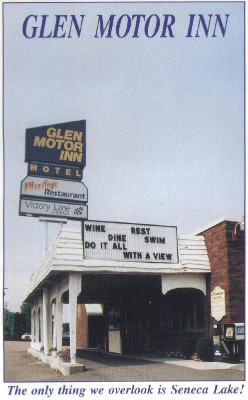 I rolled into Watkins Glen, New York, late in the afternoon on Friday, September 1, 2000. On a previous trip (Fall of 1996) I passed through the town of Watkins Glen and stopped to eat lunch at the Montage restaurant, which looks out over Seneca Lake. I recalled that the restaurant was part of a motel, but, unfortunately, when I was making plans and reservations for this trip I couldn’t remember the name of the motel. Well, I won’t forget the next time I’m going to be in the Watkins Glen area – the place to stay in Watkins Glen, if you ask me, is The Glen Motor Inn. Don’t get me wrong; the motel I stayed at on this trip was fine, but it didn’t have nearly the view offered by the Glen Motor Inn, nor did it have a restaurant attached.
Watkins Glen is, of course, most well known for the nearby racetrack, and many of the businesses in town are mindful of that fact and cater to motorsports enthusiasts. But the town also boasts Watkins Glen State Park, which contains Watkins Glen Gorge, cut by glaciers during the most recent ice age. Hiking in the gorge is great, but there are a number of steps near the upper end of the park that lead to the upper entrance parking area. Parking at the lower entrance, the one right in the middle of town, is probably the best idea. Then hike up the gorge as far as you wish, and when you turn around it’s mostly downhill. On the previous trip mentioned above, I hiked from the lower parking area up the eastern side of the gorge, climed all of the steps to the upper parking area, bought some great fudge (and a tee-shirt that says “I Made It To The Top”) from the gift shop there, then hiked back down the western rim. An arduous but enjoyable hike if you have time (I think it took me around 4 hours, as I recall).
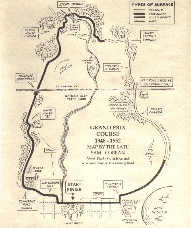 Of course, for any racing enthusiast, possibly the most interesting and memorable thing to do in the town of Watkins Glen (well, other than attend a race or other event at the current track there) is to drive the “old course,” which was used for racing from 1948 until 1952. The map at the right details the course. The old course is also marked along it’s route by roadside markers, but they are quite difficult to see unless you know exactly where to look. One of the things I found most surprising was the elevation change – up at Old Corning Hill and back down at Big Bend. The films of races from the period when the old course was used really don’t do the elevation changes any justice.
Another thing that I found interesting – and a bit scary – was how narrow the road is as it goes under the railroad underpass. For the record, I would not want to race anyone toward that underpass. For that matter, I wouldn’t want to race anyone over the grade level tracks on the other side of the circuit either.
Home Sweet Home
After spending Friday and Saturday nights in Watkins Glen, I headed for home on Sunday, September 3, 2000. Yes, that Monday was Labor Day, and, yes, I was off that day, too, but I wanted to get home a day early so I’d have time to plow through the mountain of mail I knew would be waiting, not to mention the mountain of laundry I’d been accumulating. I arrived home in the late evening and pushed my way in the front door (the house where I was living at the time had a mail slot in the door – I’ll leave to your imagination what it was like to open that door with three weeks worth of mail piled behind it).
The Great Lakes Trip had been, well, great!